Flying a drone can be dangerous to you and other riders. Fly drones only on a property you own when no riders or spectators are in the area. Only licensed drone operators should use this guide. Fly drones at your own risk.
HD TRACK MAPS
how to create your own
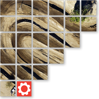
Creating an HD track map is a simple process. You'll start by taking lots of top-down images with a drone and then using software to stitch those images together. The final product is one seamless composite image. The high-resolution 4k images captured during low altitude flight result in super high-definition track maps. With an HD map, you can zoom in more for deeper insights on line choice.
HD track maps also are more current, and represent a more accurate version of the track layout than satellite imagery can typically provide. Use this same process each time significant track layout changes are made. Obviously current HD maps are preferred, but even slightly outdated HD track maps still enhance the LITPro App experience and analytical power.
Creating an HD track map is valuable and we encourage it despite all of our warnings and caveats so long as it can be done safely. If you are planning on doing one we'd love to hear about it and give you some guidance (though don't ask us how to operate your drone ;).
PRE-REQUISITES
- Make sure the drone can be flown when no riders or spectators are present.
- Make sure you are flying the drone on property you own.
- Make sure your drone is flown by a licensed drone operator, and that it can be done safely.
- At least one lap at the track using LITPro must be completed and synced before the final stage of processing of a new HD Track Map can be completed.
INSTRUCTIONS
For creating HD Track Maps, LITPro has partnered with Maps Made Easy. High-level instructions are here, but drone safety as well as drone operating instructions are out of the scope of this guide.
Compatible drones:The Map Pilot Pro App is compatible with a host of DJI drones. You can find the full list of supported drones here.
Required AppDownload the following app from the Apple App Store: Map Pilot Pro (made by MapsMadeEasy).
PrimerTo capture the images you need to have the drone operator download (and pay for) the Map Pilot Pro App from Maps Made Easy. Maps Made Easy has a website dedicated to instructing users how to best use the app to capture the images we need: Detailed Instructions by MapsMadeEasy
Once the drone operator is comfortable with the Map Pilot Pro App, the drone operator should go to the track. Someone with knowledge of the track (someone who knows the layout well) should help the drone operator create the boundaries around the track from within the Map Pilot Pro App. Set the Map Pilot Pro App to travel at the lowest elevation within reason (around 80-100 meters is usually best for "motocross" tracks, you can fly lower for smaller supercross tracks). The Map Pilot App does everything from there.
You'll need to upload the images to a shared Dropbox folder we will create. And then we're only a couple hours away from having an awesome HD track map inside the LITPro MX App.
FinallyOnce you have the images ready to upload, contact the LITPro team with the name of the track, the location of the track and a description of your flight parameters (altitude, estimated number of images), your LITPro user account and the time and date of the lap that was completed at this track and we will provide you a dropbox folder to upload to.